Have you ever ordered your favorite pizza through an online app just to be told, “we don’t deliver that far?” I am always disappointed when I can’t get my pizza delivered straight to my door. Just like having a timely pizza delivery, it is important for me to assess service industries present in a neighborhood that I haven’t visited in a long time. I take note of things such as the new restaurants, urgent care centers, and, of course, pizza places.
I often wonder what logistical decisions were made to meet the needs of the customers in the surrounding area. How does a service company, such as a healthcare organization, evaluate if they have reasonably met the needs of a neighborhood to provide the best customer service possible? Delivering the best services can come down to two major overlooked factors, drive time and distance to people served.
Improving Customer Care
If I am running a food delivery company like Grubhub, or I work for a healthcare provider who has to offer in-home nursing services, I need to have a strong understanding of drive time and distance. This insight not only provides understanding of the operational cost, but also allows service providers to gain perspective on the needs of their customers.
Drive time and distance metrics are just one way to measure customer satisfaction and the improvement of customer service. Considering the impact of these two metrics and ensuring people are within a reasonable driving distance to the services are essential. The internet hosts a wealth of resources that helped me tackle a specific client use case, and I would like to share the use case in this blog.
Tackling a Use Case
I was contracted by a client to evaluate drive time and distance for a healthcare provider who offers healthcare services for residents in a 3,000 square mile area. The drive time and distance were measured door to door for a specific type of healthcare service, starting from the patient’s location and going to a provider’s location. The client asked me to determine if there were sufficient provider locations within a reasonable distance and drive time for all residents in those 3,000 square miles.
One of the key requirements in my use case was to create a solution that would sustain current and future needs with little human intervention. Here’s a high-level overview of the various aspects I considered when approaching this client’s request.
Application Programming Interfaces (APIs) were the first thing I considered. If you are not familiar with APIs, they are Interfaces that let you access data from other domains or sites on the internet. WEB and REST are two types of those APIs that allow you to accomplish unattended data extraction over the WEB using HTTP. If you’ve never evaluated map services available online, I assure you that there are tons of information about map services available as well as information on how to use those resources.
Choosing an effective map service was an important consideration of this process. When selecting map services, I found various vendors offering map APIs on the web. Google Maps, with over one billion monthly active users, is a popular choice. However, other options like ArcGIS and Azure Maps also provide APIs to meet drive time and distance requirements. Ultimately, I recommend Microsoft’s Azure Map services due to comparable features and Microsoft’s status as a preferred vendor for many customers.
Acquiring Azure Map services was my ultimate decision forward in this evaluation. I set up a new Azure free account. The free account gave me a $200 free credit for 30 days and additional free services for 12 months.
Azure maps have a “pay as you go” model. The cost is based on the number of transactions per month. I receive thousands of free transactions each month, with subsequent transactions at 50 cents per 1,000, which is quite reasonable compared to other services.
I highly encourage anyone delving into this topic to do more research about the types of APIs, cost, transaction types, number of transactions, and how the number of transactions are computed before committing to a product or a service. Another driving factor for my choice was that Azure Map services offered a route service that collects the exact driving time and distance for any time of the day, even on a future day.
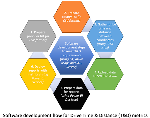
Creating a solution based on my research and available tools was the final step to providing a solution to the client. I used C# as the primary programming language and SQL Server as my database for this solution. I used JSON and CSV as primary data formats. I mapped many 3,000 square mile boundary coordinates to various healthcare provider locations and acquired driving time and distance using Azure Map APIs. Below, you will find a high-level figure that demonstrates how the solution is created. A detailed description of the steps taken is beyond the scope of this blog.

Calculating the drive time and distance is just one way metrics could be intertwined with good customer service. I demonstrated to my client that the healthcare provider strategically positioned an appropriate number of locations across the 3,000 square mile radius. Each customer could access services within an acceptable drive time and distance. By achieving this balance, the provider ensured efficient service delivery and customer satisfaction.
Next time you open a pizza box, you’ll hopefully chew on the idea of how drive time and distance can impact service delivery.